The Kassel-Steig
Mönchehof - Helfensteine (19km)
The Kassel-Steig is a 159 km long panoramic trail around the Kassel Basin. Would you like to learn more about the Kassel-Steig?

The Kassel-Steig

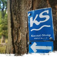
Waymarking from the Kassel-Steig
The Kassel-Steig is a long-distance hiking trail in Germany that traverses the diverse landscape of the North Hessian Uplands, running from the city of Kassel to the Edersee. The trail is approximately 170 kilometers long and offers hikers the opportunity to explore the beauty of the North Hesse region.
Before reaching Mönchehof train station, we turn right out of the village. Passing by the Glockenteich (Bell Pond), we reach a forest cemetery. A short while later, we find ourselves in the Espenau district of Schäferberg. After crossing the B7 road, the trail runs parallel to the road for a while before finally turning back into the woods. From here, we walk along the edge of the forest, passing the uppermost houses of Heckershausen and eventually reaching a beautiful barbecue area. Continuing on a path to the right, we cross several fields and meadow paths to reach the Keischel Nature Reserve.
Gradually, but steadily, we descend a bit into the small village of Weimar. From the local train station, we leave the village in the direction of the camping site and Badesee Bühl (Bühl bathing lake). After a few field paths, we hike uphill through the forest, and just before Helfenstein, there is a gate right in front of the glider camp. This is where the Habichtswaldsteig (Hawk Forest Trail) begins.
Indeed, like the Märchenlandweg, the section of the Kassel-Steig on the Nord Süd Trail is a classic “transitional route.” It may not be very challenging or varied, but such paths are necessary as well.


