The Sigwardsweg
Steinhuder Meer - Porta Westfalica (101km)
The Sigwardsweg is a tourist and spiritual hiking trail established in 2009. Would you like to learn more about the Sigwardsweg?

The Sigwardsweg

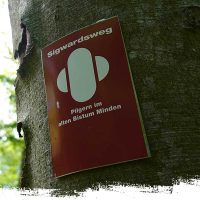
Trail Marking of the Sigwartsweg
We now follow the Sigwartsweg in a southwest direction until we reach the village of Bergkirchen. In good weather, there is a magnificent view of the Schaumburger Land to Porta Westfalica in the south before reaching the village. Here, you see the beginnings of the German Mittelgebirge for the first time, an incredible moment for every Thru-Hiker. Behind Bergkirchen, the ascent into the Rehburger Berge begins from Wölpinghausen. Just before the village of Wölpinghausen, we reach the 900-kilometer mark. Congratulations!
A ridge leads us past the Wilhelmsturm to Bad Rehburg. The trail continues through the Rehburger Berge, passing a dinosaur park towards Loccum. The pilgrimage route follows a historic network of paths and passes by viewpoints and picnic areas. At the Luccaburg, an old ruin, you can certainly set up your tent for a night.
We continue along the Fulde for a bit before reaching the Cistercian monastery Loccum, founded in 1163. Here, there is the opportunity to stay in the Pilgerhaus. However, advance registration by phone or email is required. After Loccum, the trail heads west through a forested area to Petershagen-Heimsen. Here, we catch the first glimpse of the Weser, the river that we will more or less follow in the coming weeks. Initially, we follow a beautiful path along the Weser, but later it becomes unfortunately asphalt-heavy until we reach Petershagen-Schlüsselburg. There is accommodation available in the Pilgerherberge “Altes Pfarrhaus.” At the end of the village lies the noteworthy historic Scheunenviertel. After a short time, we cross the Weser Canal, where a path leads us back to the Weser. After 2.8 km, we reach Stolzenau, offering plenty of shopping options and a campground.
Now, we continue in a northerly direction. The trail initially follows the Weser through the town and then proceeds along quiet farm and field paths to Schinna. Beyond the village, it continues through rural areas until reaching Nendorf. After Nendorf, the trail initially heads southeast until reaching the Weser. Along the river, we arrive in the charming Weser village of Buchholz. The small village of Raddestorf is reached after another 3.5 km, leading us south to Ovenstädt. There, directly by the Weser, a dreamy bench offers a spot for a pause. From Ovenstädt, the trail continues upstream along the Weser. After 5 km, we reach Petershagen. In the village, there is a youth hostel and many shopping options. Now, the trail leads us initially through a small wooded area, and later it continuously ascends along the Weser until we reach the cathedral city of Minden, nearly 15 km away. Here, we hike past the impressive Schachtschleuse Minden and further through the city center until being led along the Weser again at the Glacis-Brücke. With the Kaiser-Wilhelm-Denkmal in view, we quickly leave the city behind. Now, the ascent into the Wiehengebirge begins. Past the Moltketurm, we reach the imposing Kaiser-Wilhelm-Denkmal.
At the Kaiser-Wilhelm-Denkmal, the steep descent begins to subsequently cross the Weser again. Congratulations, Porta Westfalica is reached, marking the trailhead of the Weserberglandweg.


