History of
the North South Trail

The beginning
Official North South Trail Hiking Marker
That was roughly my first search query when I started looking into long-distance hiking trails. To my surprise, apart from the European long-distance paths, there was nothing comparable in Germany. Why not?
Is our country too small, too uninteresting? Is it not hip enough, or is it too conventional to hike your own country? Well, before tackling something as big as the Appalachian Trail or the Pacific Crest Trail, shouldn’t you start with something smaller and shorter, right? So, I packed my gear and tried the Rheinsteig.
By the halfway point, I realized just how beautiful our own country is. I imagined what it would be like to traverse the country from north to south, but not on the direct route like the German section of the E1, but longer and more comprehensive. On the Rheinsteig, my dream of a “German Thru-Hiking Trail“.
A trail that would be roughly comparable in terms of distance and physical challenge. Is that even possible?
We don’t have true wilderness in Germany, nor the remoteness of the American mountain ranges. But what Germany offers is so much more: stunning nature, diverse trails, and history coming alive at every turn – ancient castles, medieval city walls, villages, and paths that have been walked by people for hundreds of years. A perfect blend, really, of wilderness trails and the overcrowded Camino de Santiago with its perfect infrastructure. The best of both worlds, so to speak.
After over two years of intensive planning, I have now completed the NORD SÜD TRAIL. At 3,700 kilometers, it is Germany’s longest long-distance hiking trail.

THE FIRST THRU-HIKE
When the route of the Nord Süd Trail (NST) was designed in 2018, the idea of creating separate trail markings wasn’t initially part of the plan. The NST leverages the excellent, dense network of already existing top-tier and premium hiking trails. At that time, the Nord Süd Trail existed only as an idea in the form of a GPX track. Essentially, the NST was nothing more than a GPS hiking suggestion, similar to those uploaded daily on platforms like Komoot. Therefore, the NST didn’t require any “permission” from hiking clubs or authorities. It was only through this approach that a long-distance trail could be realized so quickly and without bureaucracy.
In 2020, the first complete thru-hike was undertaken by the trail’s initiator and YouTuber, “Soulboy”. This hike laid the foundation for the Nord Süd Trail. The entire journey was documented on his YouTube channel, “Soultrails”, and all shelters and accommodations along the way were recorded and mapped.
Even during this first thru-hike, a large number of long-distance hikers, hiking bloggers, YouTubers, and outdoor enthusiasts rallied around the idea of a national long-distance trail.
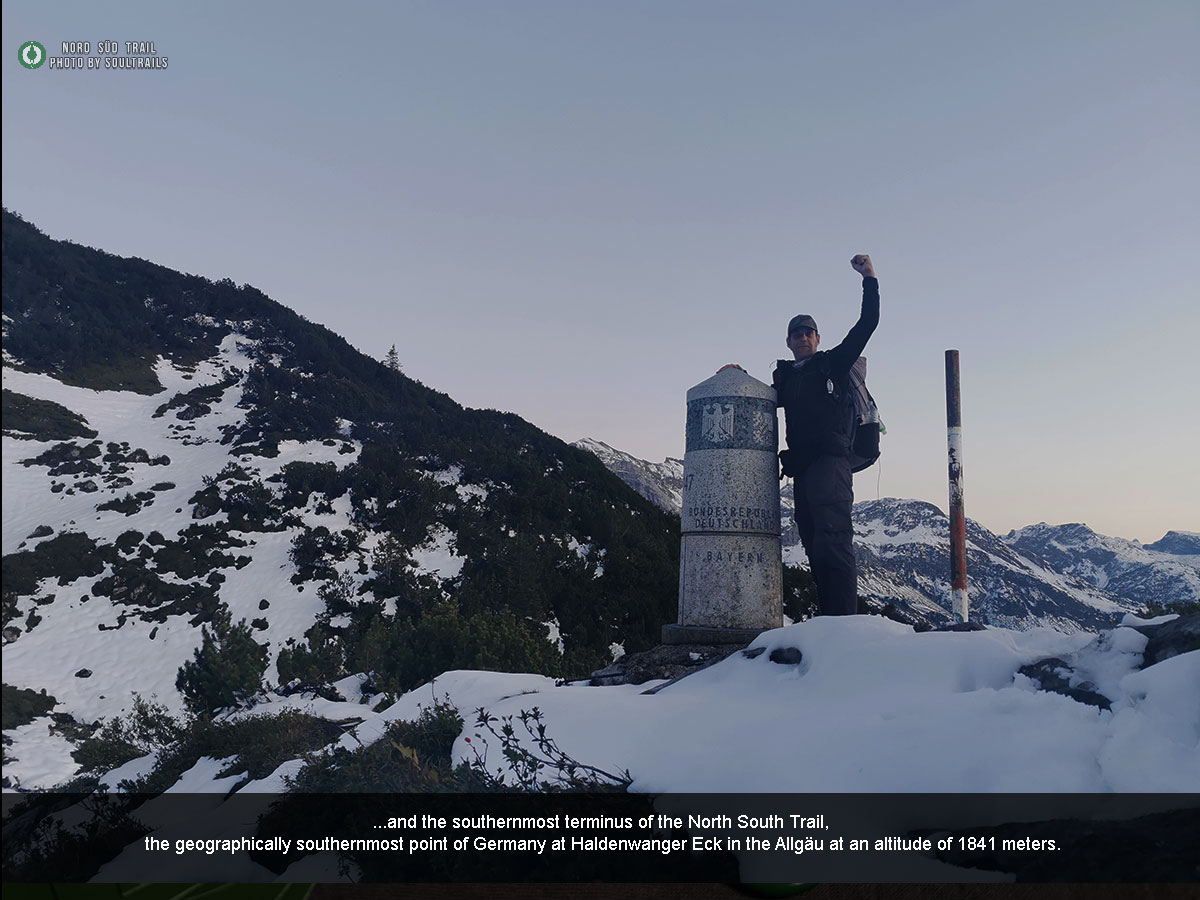
NO PAIN, NO DIRT, NO HALDENWANGER ECK
So, what exactly is the NST?
The Nord Süd Trail is not a long-distance hiking trail maintained, managed, or marked by one or more hiking clubs. Unfortunately, Germany is not yet at a point where different stakeholders come together to jointly establish a long-distance trail that runs exclusively through the country. It’s not even possible to install a “Halfway Point” – the midpoint – on one of the most famous long-distance trails, such as the Westweg.
What to do, then?
In today’s world, it’s no longer absolutely necessary to fully mark a hiking trail. Almost everyone uses GPS systems, which are very accurate and work reliably offline. Additionally, Germany already has a dense network of top-tier and premium hiking trails. So why not simply connect these existing trails?
For most hiking associations, however, the topic of “thru-hiking” goes completely unnoticed. It is neither acknowledged nor taken seriously. Additionally, there’s the issue of overnight accommodations, which gives many officials in these associations headaches. But even here, a shift in thinking is slowly taking place, as seen in the creation of legal trekking camps. This means the basic conditions for a national thru-hiking trail are actually in place.
Originally, I would have loved to develop this project from the start in collaboration with the German Hiking Association (Deutscher Wanderverband). However, as it turned out, that unfortunately wouldn’t have worked. For this very reason, I also didn’t bring up the idea for discussion in relevant outdoor forums. Because if there’s one thing I’ve learned, it’s this: on the internet, everything gets talked to death. In hindsight, this decision proved to be absolutely right. Sometimes in life, you just have to take things into your own hands and see where they lead.
Is the Nord Süd Trail now an “official” hiking trail?
Actually: yes. With the ongoing marking and the increasing number of permits for careful signage, it is a hiking trail like any other – and yet a little different.

The first route of the 2020 NST
The birth of the North South Trail initiative
But the NST is what we all make of it. Every long-distance trail came into existence because people walked it long before it was marked by hiking clubs and associations. Some of today’s very famous long-distance trails, such as the Te Araroa Trail in New Zealand, the Via Dinarica, or the Sentiero Italia, were designed by linking existing long-distance trails. The future will show whether and how the NST establishes itself, but one thing is certain: there is undoubtedly a demand for a very long hiking trail within Germany.
What started as a small private initiative has now grown into a large network of volunteers, experienced thru-hikers, trail stewards, and hiking guides. This marks the birth of the “ “Initiative Nord Süd Trail.”
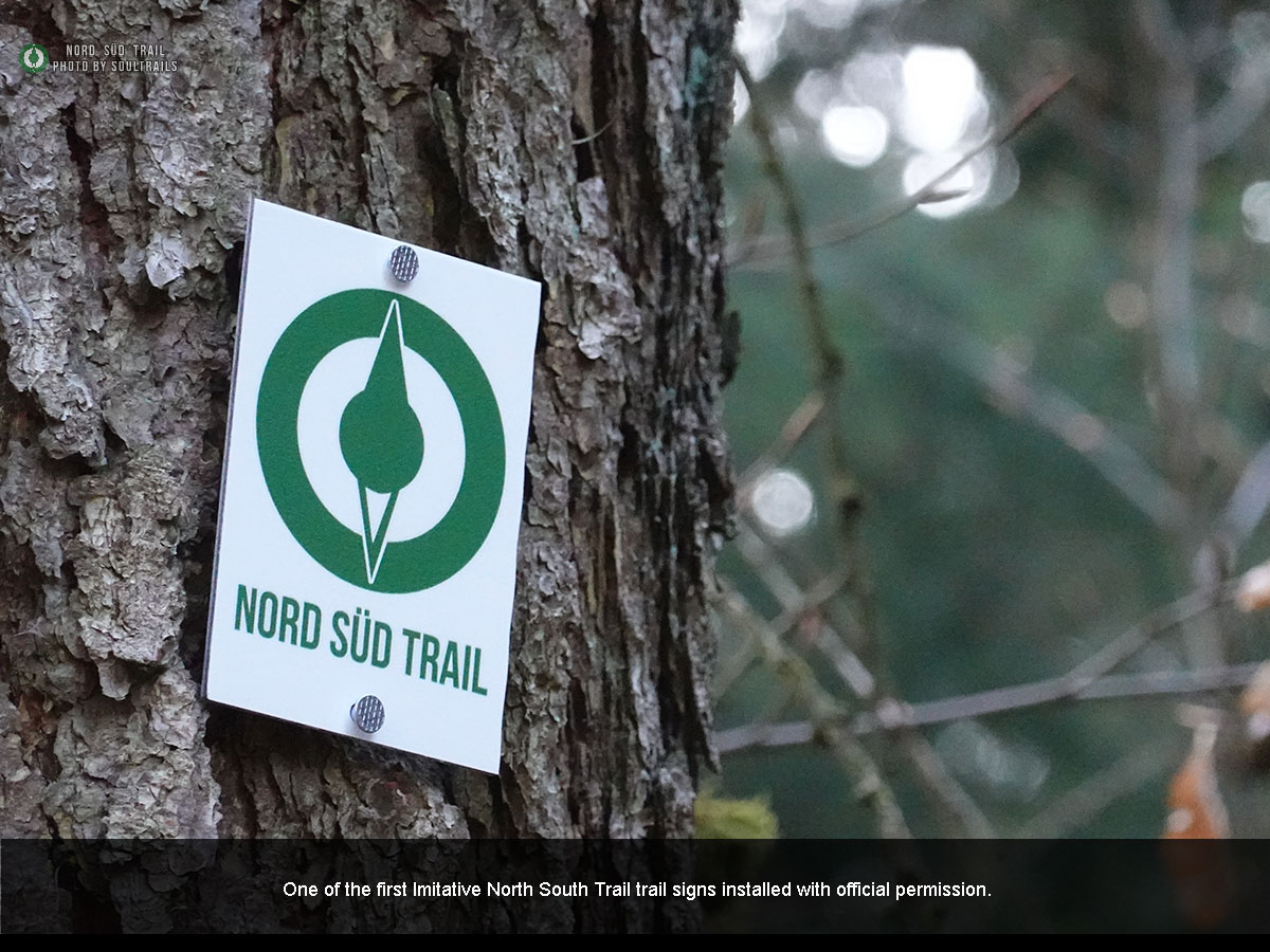
Over time, the call from the long-distance hiking community for “proper” signage for the Nord Süd Trail (NST) grew louder. As a result, the Initiative Nord Süd Trail began coordinating with relevant stakeholders – including hiking associations, tourism offices, and authorities.
Recently, we were able to welcome the Region Hannover, the Naturpark Steinhuder Meer, the city of Flensburg, the Heidschnuckenweg, the Bodenseekreis, the district of Lübeck, the Veldenz Wanderweg, den Pfälzer Höhenweg, den Saar-Rhein-Wanderweg, den Lahn-Dill-Bergland-Pfad and the Rothaarsteig as our first official partners. From all of them, we received permission for careful signage of the Nord Süd Trail on their respective trail sections. Further discussions with authorities and hiking associations along the route are already underway.
This is a huge success for the Initiative Nord Süd Trail. But the most incredible thing is the response from you, the long-distance hiking community. With few exceptions, the NST is overwhelmingly perceived as positive and enriching – something that was hardly expected at the beginning.
Of course, we will continue to seek dialogue with the German Hiking Association (Deutscher Wanderverband) and all responsible associations.
After all, it is almost exclusively their trails that we use, and we will always highlight and promote them accordingly. However, we are convinced that the Nord Süd Trail will soon be seen as a win-win situation for everyone involved.
If you’d like to learn more about the signage of the NST, you can do so on the „Trail Stewards and Signage“ page.
The NST - it is our way
Another highlight of the Nord Süd Trail is the „Find Penguins“, app, which we use as a digital stamp book. But this social media app has become so much more. Even during the first thru-hike, a large, helpful, and friendly community quickly formed. Here, you can virtually accompany thru-hikers, arrange to meet them, or surprise them along the way with a little „Trail Magic“.
By now, several hikers have already completed the Nord Süd Trail in its entirety, and this year, many more are taking on the challenge of tackling Germany’s longest long-distance hiking trail in one go. At the same time, the number of sektion-hikers, who complete the trail in segments over several years, is growing month by month. The idea of a digital stamp book has been enthusiastically embraced by the hiking community.
What began as a “one-man show” has grown into something much bigger. A small private initiative has evolved into a large network. But ultimately, it’s up to all of you to make the Nord Süd Trail THE German thru-hiking trail and to discover your own country on foot. Hike and enjoy the trail, share your experiences in blogs, YouTube documentaries, or travel journals on “Find Penguins” – and above all, have fun hiking!
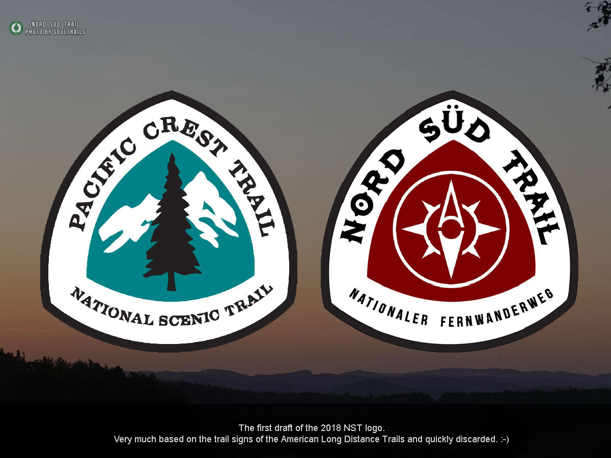
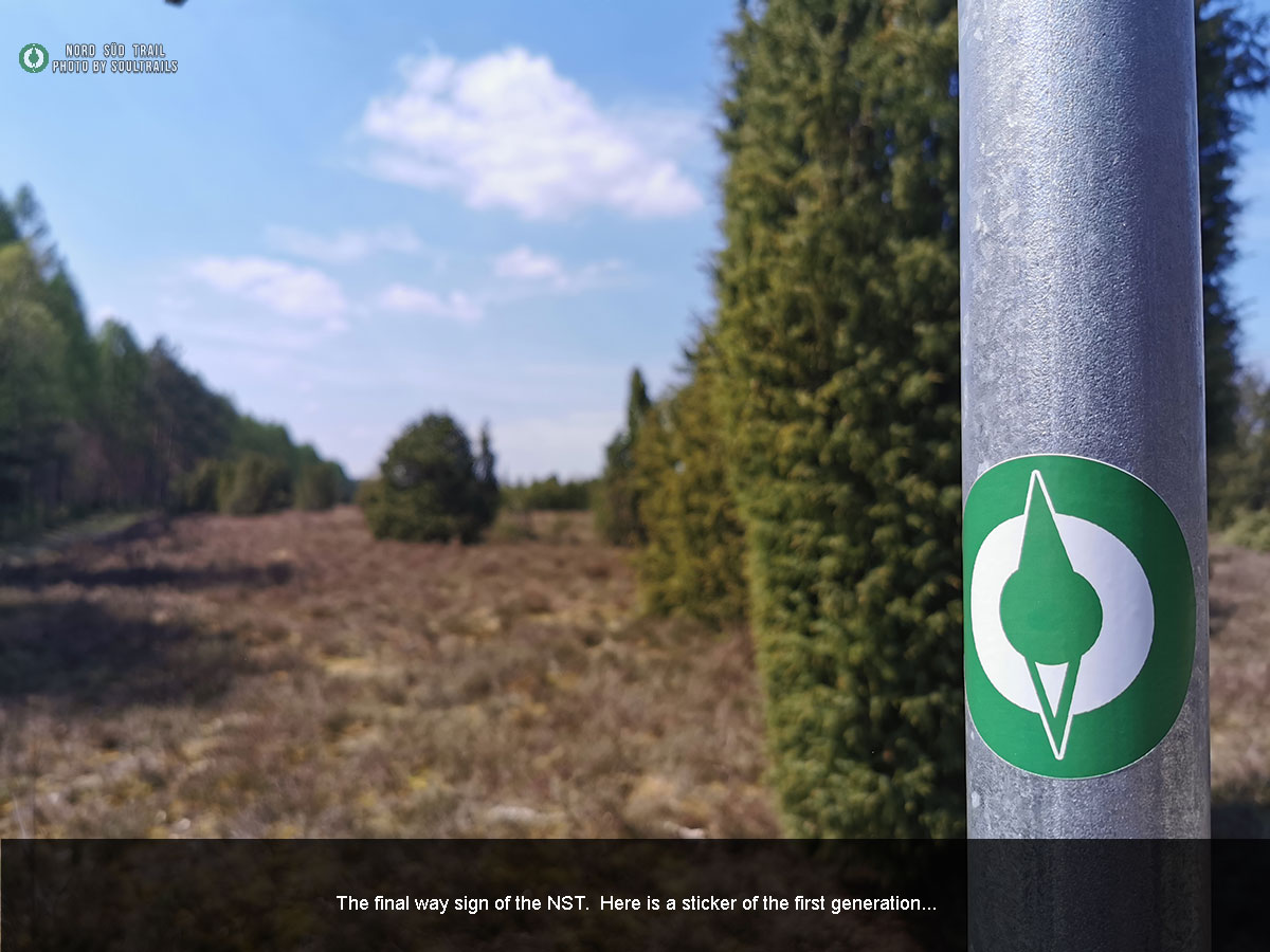
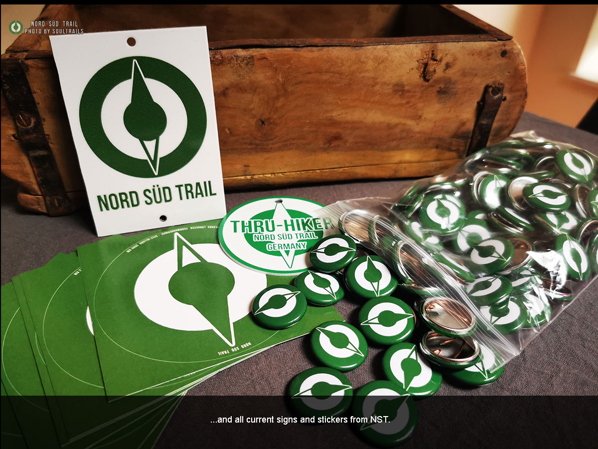
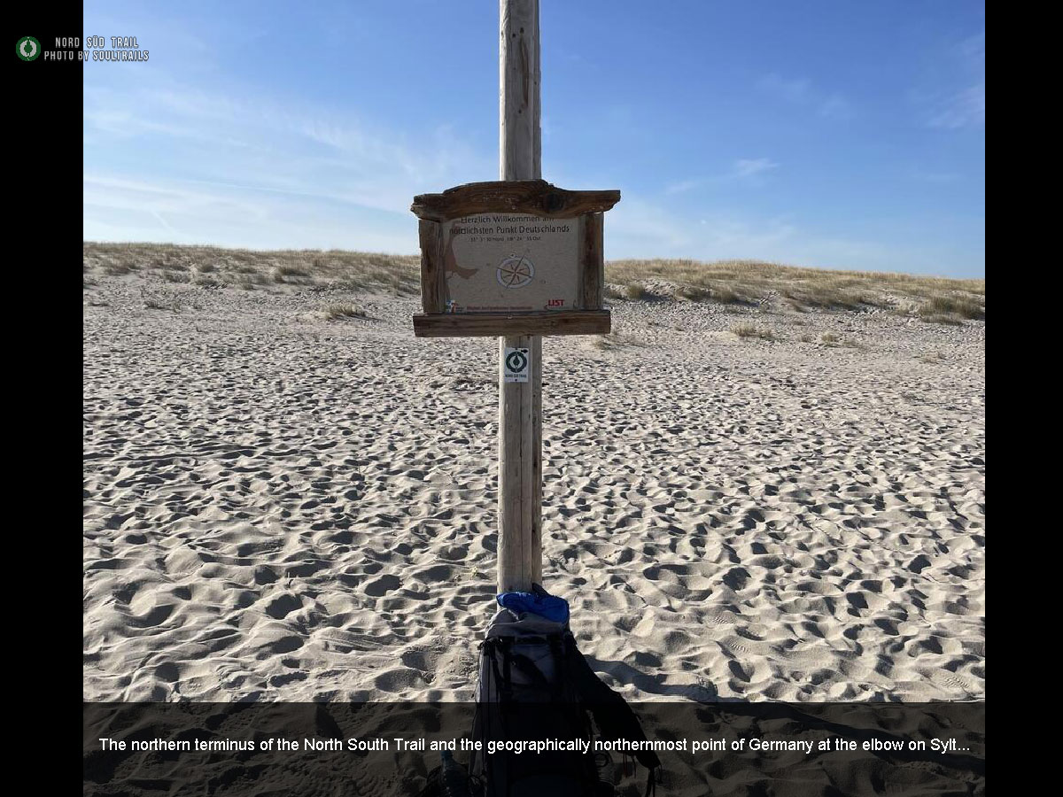
It was here, on the Rheinsteig, that the idea for a national long-distance hiking trail first began to take shape. Originally planned as training for the Appalachian Trail, YouTuber “Soulboy” realized how incredibly beautiful his own country truly is.But one question remained: Why isn’t there a thru-hiking trail in Germany? Every year, thousands of hikers travel abroad to walk such trails — yet nothing similar existed at home. Something had to change. The Rheinsteig can therefore rightfully be called the birthplace of the Nord Süd Trail. In early 2018, the first route drafts were created. The original starting and finishing points were planned to be the Nordertor in Flensburg and the Imperia statue in Konstanz.Back then, the trail also passed through the Teutoburg Forest.But something was still missing — a name, a deeper idea.In its initial form, the route felt too similar to the German section of the European Long-Distance Trail E1. By the end of 2018, work on the project had slowed down. Then, purely by chance, YouTuber Soulboy came across Christof Herrmann’s project “Deutschland der Länge nach” (“Germany Lengthwise”), in which Herrmann hiked from Germany’s southernmost to its northernmost point.After a bit of research—and the realization that both points had a clearly defined terminus—the idea finally clicked. The trail now had a true start and endpoint, as well as its name: the Nord Süd Trail. A huge shoutout to Christof Herrmann—without his inspiration, this trail would most likely not exist today. In early 2019, work began on finalizing the trail’s route and overall appearance. A website was to be created, and the idea of the trail introduced on the YouTube channel “Soultrails.” Designing the logo—which would also become the official trail marker of the NST—proved to be both practical and symbolic: a round compass needle that can be rotated as needed, always pointing the hiker in the right direction. By the end of 2019, the first official route of the Nord Süd Trail was completed. At that time, the trail stretched over a total distance of 3,382 kilometers. In addition to newly created sections, many well-known regional long-distance hiking trails were already integrated. Some smaller routes—such as the Hessenwege or the Dillhöhenweg—are no longer part of the current version, as the trail’s course has gradually evolved over the years. On February 20, 2020, the time had finally come – the trail and the entire project were officially presented to the public. In a 30-minute video, the idea, the motivation behind the trail, and the planned route were explained and introduced. Even back then, the response from the hiking community was – with only a few exceptions – overwhelmingly positive and enthusiastic. There was also the opportunity to follow the first thru-hike “live” via a social media app called Find Penguins – a very smart decision, as time would later prove. They say the first step is always the hardest — and for the Nord Süd Trail, that moment came on April 20, 2020. That’s when the trail’s initiator, Soulboy, set off along the Heidschnuckenweg. Because of the ongoing COVID-19 pandemic, it wasn’t possible to start from Sylt as originally planned — though this was later made up for. Among thru-hikers, such a change in route is nothing unusual; it’s a well-known practice called a “flip-flop.” Perhaps it was precisely because of the pandemic and the resulting lockdown that over 1,700 people gathered on the social media app Find Penguins to virtually follow the very first thru-hike.Thus, April 20, 2020 can rightfully be considered the birthday of the Nord Süd Trail. After five and a half months and more than 3,900 real kilometers (including detours, filming, and other extra miles), the time had finally come — the first complete thru-hike of the Nord Süd Trail was accomplished. With the hike itself completed, the real work was only just beginning: creating the film documentary, building the official website, and establishing a social media presence. But one big question remained: Would other hikers follow in the next year — or would the Nord Süd Trail fade into obscurity? The dream actually came true: already in the very first year, the first thru-hikers set out on the Nord Süd Trail. Although Germany was still under strict COVID-19 regulations in 2021, a few determined hikers decided to take on the NST and walk it from end to end. At that time, the trail was still being hiked in the original route envisioned and designed by Soulboy. On March 6th, 2021 at exactly 12:00 PM, the time had finally come – the official Nord Süd Trail website went live. With the kind support of “Esha”, who developed the site in his free time and filled it with the first pieces of content, the project could now truly begin. From the very start, the website included several important features, such as an interactive map, a shelter map, and the NST forum. The Nord Süd Trail website can be accessed at: www.nordsüdtreil.de | www.nordsuedtrail.de | www.thruhike.de On the section between Dillenburg and Herborn, the NST previously followed the Dillhöhenweg (on the right side of the Dill River). Unfortunately, this route wasn’t ideal and didn’t really encourage hikers to make the detour to Herborn. The new route now leads hikers along the Lahn-Dill-Bergland Trail, which is much more enjoyable to walk and makes far more sense in terms of flow and scenery. The goal of the NST is to combine as many officially marked trail sections as possible. When the NST was first launched in 2020, only 387.7 km of the total 3,382 km were unmarked — that’s 11.46% of the route. With a new route adjustment along the “Western Tangent”, the main variant has been extended by 142 km. As a result, the NST will now have a total length of 3,513 km. The unmarked sections have been reduced to just 7.7%, and the overall trail appearance and quality have become noticeably more appealing. On September 7th, Radusel passed away on the Rheinsteig. This news shook us all deeply and filled our hearts with sorrow. The entire Nord Süd Trail community will never forget Radusel. “Up until now, my journey felt natural: I set out to do it, so I’ll do it—no matter what happens. Only today did I truly understand what a privilege it is to experience something like this once in a lifetime. What a vast dimension this whole thing really has! And yet, it’s made up only of small fragments. Around 1,600 km! Unimaginable! And still, I already feel the melancholy of having to leave this perfect world behind.” Michael “Radusel” Radetzky R.I.P. In early 2022, the first NST enthusiasts came together to discuss the official signage of the trail. Leading the way was Peter “Hobble”, the founding father of the Initiative Nord Süd Trail. Another key figure was Frank “Freestyla”, one of the earliest and most dedicated supporters of the NST. In his spare time, he produced an outstanding promotional film, helping to bring the trail’s spirit and vision to life. The Nord Süd Trail received a new and more scenic route between Hann. Münden and Brilon. The old path along the Hessenwege had become partially impassable and, in some areas, no longer existed. In addition, the proportion of asphalt was somewhat too high. Another major advantage of the new route is the availability of trekking sites along the Habichtswaldsteig and Diemelsteig, making this section both more enjoyable and practical for long-distance hikers. On April 21, 2022, we received official approval from the district of Harburg and all parties involved with the Heidschnuckenweg that we are permitted to display the Nord Süd Trail logo alongside the official HSW logos. This authorization came with several conditions — for example, the NST logos must be mounted on insertable add-on signs. The first of these signs were installed on February 20, 2023, by Peter “Hobble”, marking a major milestone in the history of the Nord Süd Trail. All eleven municipalities have given their approval, officially paving the way for the signposting of the Nord Süd Trail in the region. This marks another major success for the NST Initiative. In addition to many permissions for our trail markers — for example, on renowned routes such as the Rothaarsteig, Rheinsteig, and other premium trails — we are now receiving an increasing number of official authorizations as well. The Nord Süd Trail is now featured in the hiking maps of KOMPASS-Karten GmbH. This applies not only to the digital premium version (KOMPASS Pro, €1.64 per month), but also to the upcoming printed editions of their renowned hiking maps. For us, as the NST Initiative, this marks another major milestone in the establishment of a true thru-hiking trail in Germany. On January 3rd, 2025, another major milestone for the NST was achieved! The Nord Süd Trail now has an official starting point at the Ellenbogen on Sylt, marking the northern terminus of the trail. In collaboration with the Nature Conservation Authority of the Nordfriesland District and the landowners of the Sylter Ellenbogen, an official trailhead sign was installed. Our special thanks go to Mr. Thomas Diedrichsen and, of course, to our trail coordinator Peter “Hobble.” So, dear thru-hikers — hike on! The Nord Süd Trail is getting its very own hiking app, containing all the essential information about the trail — your digital Trail Angel, so to speak. Instead of developing a separate app, we embraced the community approach. This app doesn’t just feature the NST, but also includes many other long-distance hiking trails across Germany. It’s available for both Android and Apple smartphones — and, of course, completely free of charge. For us at the NST Initiative, this marks yet another major milestone in the ongoing development of the Nord Süd Trail.Nord Süd Trail Timeline


THE HIKING DICTIONARY
“Thru-Hike? Trailmagic? Trailangel? Do these sound like Bohemian villages (a German idiom for something unfamiliar) to you? Then check out our “Fernwandern Lexicon”! A simple collection of terms and concepts related to long-distance hiking and thru-hiking.
 for Wordpress and WooCommerce.")